

articles/Landscape/scotland
Scotland - a look at what's under your feet as you walk in the Highlands
by Mike McNamee

This was a catch-up tour of the photographic hotspots of the Highlands, taking in some of the things missed (due to time or bad weather or both) in 2012 and in some places a return after more than 30 years' absence. The trip included an initial trip to Skye by boat (the only way to arrive on Skye!) and revisits to Glen Brittle and the Trotternish areas. Both were last visited in 1979. Some things change little; it was May back then and we were climbing in deep snow on the Cuillin Ridge, the tops were once again snow capped!
From Skye, we hopped a Calmac ferry from Uig to Tarbert, Harris in the Outer Hebrides, then up to Lewis, back to the mainland via Ullapool to Kinlochewe in the Torridon area and then two hops home via Glen Coe and Kirby Steven - in total, a little short of 2,000 miles.
Geology The trip took in much of the classic geology of the Highland area. It is always striking to ponder on the slow and laborious assembly of Scotland from disparate parts of supercontinents so many millions of years ago. A massive volcanic upheaval occurred more recently (a mere 60 million years ago) when the Americas and Greenland departed from the rest of Europe, as the Atlantic Ocean widened. This was accompanied by dramatic thinning of the Earth's crust, which allowed huge intrusions of volcanic material, which sliced through the already present landscape.
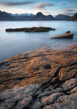
The Torridon area is quite different but equally dramatic; here the landscape has been carved out of just the sandstone, to created the giant mountains of Liathach, Beinn Alligin, and Slioch. Beinn Eighe is also in the area but has the unusual feature of being upside down with the older rocks (quartz) on the peaks.
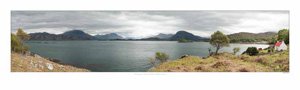
The Outer Hebrides are different again. They are typified by a layer of Lewisian gneiss, (the oldest rock on the planet, which is hard and impervious) forming the mass of bogs and lochans which typify the Uists in particular. The flat landscape of the southern islands is relieved by the mountain ranges in the Harris area, which were originally squashed up by mountain-building activities.
Skye Geology Skye has some very complex geology in an already complex area. Our drive from the Armadale ferry terminal to the campsite at Glen Brittle (voted by Daily Telegraph readers as the best in Europe) took us through nine distinct forms of rock, spanning millions upon millions of years. All of these contribute to the Skye landscape which so enchants photographers.
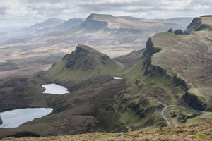
It is not all millions of years old. The collapsed escarpments of the Trotternish area only tumbled down about 6,500 years ago. It must have been one hell of a bump in the night as blocks the size of multiple soccer pitches detached themselves and tumbled down the mountainsides to finish upside down at the base of the hill. The area is a magnet for walkers and photographers, indeed it looked like a Lee Filters convention on one of the outcrops which overlooked the ridge!
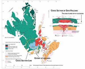
The Cuillins themselves are the jewel in the crown of Skye and are the most spectacular range of peaks and ridges on the British Isles. Their formation began 2,800 million years ago after which a sandwich was made of Lewissian gneiss, topped with Torridonian Sandstone, topped with a thick layer of volcanic lava from previous eruptions. Then, 60 million years ago, the Americas and Greenland started to drift across the widening Atlantic Ocean and the accompanying thinning of the Earth's crust allowed the formation of the largest volcanic complex of the British Isles. The underground core of the complex was an upside-down, conical pyramid, extending about 20 kilometres across at its widest, highest part. This remained in place, having burst through to the surface in a few places, and then took millions of years to cool, allowing the rock to crystallise very slowly to the coarse-grained structure which gives the Black Cuillin gabro its fine climbing grip. Very much later, the various ice ages formed glaciers which carved down many thousands of feet from the surface to expose the cone of rock. At the same time the forces of nature got to work gouging out the valleys and corries of the area as well as frost shattering any rock exposed to the air.
The diagrammatic cross-section cuts an imaginary curve from Talisker (fine distillery!) across Glen Brittle, through the Black Cuillin (Sgurr Alasdair), across Loch Coruisk and then upwards through the outlying peaks of the Red Couillin (Marsco). The Red Cuillin are the remnants of massive bubbles of granite magma which lay well below the surface until the glaciers planed the rock away to reveal them. They are rounded because they are inherently a much tougher form of rock with a finer grain because the smaller size of the magma bubbles allowed them to cool more rapidly than the huge cone of rock at the centre. This is the largest and most intensely mapped volcanic area of the British Isles. Professor Harker started his studies in 1870 and published in 1903.
This then is the underlying structure which gives the Cuillins their fabulous ridges, peaks and secretive, sparsely visited corries. You need to be a hardy soul to visit many of them and to get along the entire ridge is a major mountaineering expedition for climbers armed with ropes and equipment.
Lesser mortals have to make do with photographing them from afar!
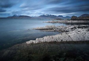
Paul Gallagher's shot above illustrates the difference between the rounded Red Cuillin in the right-hand third of the skyline and the jagged Black Cuillin to the left. This shot was taken from Tarskavaig, which lies on the north-west coast of the Sleat Peninsula. Paul's shot, opposite, brings the point out even more clearly; taken from Elgol and slightly nearer the Cuillins, the view is looking through a gap in the Black Cuillin to Marsco (Red Cuillin); Blaven (Black Cuillin) is out of shot on the right.
Note also the snow lingering on the Black Cuillin but not on the Red, frost shattering created the distinctive craggy ridge which makes the traverse so technically challenging.
Tarskavaig itself is an area that has been subject to an ongoing controversy over its origins. Originally thought of as close relatives of Torridonian rock their chemistry does not support that view. The area is visited via a narrow and very hilly road that loops off the main road from Armadale to Broadford - we should know, we cycled it a few years ago!
Geology of The Outer Hebrides
The Outer Hebridean chain lies some 25 miles away from the Scottish mainland (less from Skye) and extends some 130 miles, north to south.
It is separated geologically from the mainland, for although it shares the Lewissian gneiss, the actual rock is a closer relative to that of Greenland (a puzzle that is presently unsolved). It is postulated that the Outer Hebridean rock was moved alongside that of the mainland around 420 millions years ago when three supercontinents collided. Then, when Greenland set off across the widening Atlantic Ocean some 60 millions years ago, the Hebrides were pulled away just a little but did not follow, to leave the islands isolated if not partly similar in underlying rock. However, unlike the mainland, there is no evidence of the Outer Hebrides being buried under thousands of feet of sandstone sediment when the newly assembled Scotland was sitting astride the equator and the Old Red Sandstone continent was being laid down. Where the sediments went is a mystery but one theory is that they are buried under the Minches, away from the prying hammers of geologists!
The remaining geology is thus rather simplified, the underlying plane of Lewissian gneiss creating an outcrop and lochan landscape, topped by peaty bogs. This makes it very pretty but hard walking! Only in Harris is this geology disturbed by some volcanic activity which pushed up the rounded granite hills of the south.
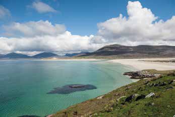
The jewels of the Outer Hebrides are its machair hinterlands and pure white beaches. Both are untroubled by the feet of many tourists - you can photograph all day long with only seals for company. The purity of the water topping the white sand gives a turquoise to the water which is Caribbean in effect and stuns visitors seeing it for the first time. The minke whale that came to play in the bay just off the campsite also seemed to like it!
Torridon Geology
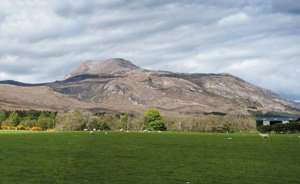
The Torridon area is different to Skye. Here the landscape has been carved out of sandstone by glacier action with little help from volcanic activity. When Scotland's jigsaw pieces were scattered about on the supercontinent Pangaea they spent a long time drifting from the southern hemisphere before crossing the equator. Here they met a dry, windblown climate which depositing many miles of ground up rock on top of the older Lewissian gneiss to form the Old Red Sandstone continent. These separate pieces of Scotland were brought together by later tectonic plate movements and the assembled Scotland ended up where it is today. At this stage the various ice ages got to work and planed off the miles of sandstone rock before being slowed down by the very hard gneiss underneath. This left massive 'hummocks' of sandstone which we now know as the Torridonian Giants. Most famous are Liathach, Beinn Alligin, Beinn Damph and Slioch but the other peaks, hidden away from the road, are equally impressive.
Beinn Eighe forms part of the Torridon group but is an outsider that has been turned upside down by the mountain-building activity which turned it turtle so that it is topped by newer quartz when it should rightly be the other way round. The layered deposits of sandstone give the mountains the surface form that they have today, a huge layer cake of sills and terraces which are particularly emphasised by a snow fall, and form winding narrow paths along the summits.
Applecross
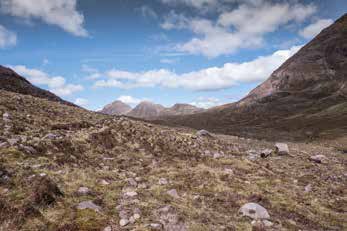
The Applecross Peninsula lies south of Torridon and its remoteness is protected by the two scary roads which lead in. The easy route is a mere 38 miles and takes about two hours but is very pretty (above); the infamous Bealach na Ba is a shorter way out and a serious challenge for a long-wheelbase motorhome!
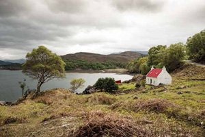
One of the holiday lets on the peninsula is still restocked from the sea.

B.P.P.A. LIMITED
The Society of International Nature and Wildlife Photographers (SINWP)
Clwyd Chambers, Clwyd Street, Rhyl, Denbighshire, LL18 3LA, UK
Company Reg 0392 2894 | VAT number 790 4289 05
Tel: 01745 356935
Corporate Partners


Newsletter: Subscribe here
SINWP Bird Photographer of the Year
London Photography & Video Show - Europe's Largest 'All-Welcome' Photographic Convention | Partner Societies | Privacy