

articles/Landscape/gallagherssutherland
Gallagher's Sutherland
by Mike McNamee

Mike McNamee goes in search of landscape at the very top of the British Isles on a route planned, illustrated and captioned by Paul Gallagher.
This is a personal story, a journey in search of the landscape of Scotland. The north west Highlands are a long way from Cheshire and an even longer way from middle or southern England. The number of people who have never crossed the Esk into Scotland is sometimes quite surprising. In these days of well-travelled holiday makers it is easier (and cheaper) to hop on a plane to the Costa del Sol than it is to grind your way the 650 miles from London to the top of the country we live in.
So, for our overseas' readers contemplating a visit and for all the English who have never ventured north, here is what you can expect. This is not a glossy tourist board view of Scotland (see call-out box about the Highland Midge) but an honest assessment of why it is worth the journey for those yet to make it, and what you are likely to endure!
Scottish scenery is the result of more than 4,000 millions years of geological development which involves some of the oldest rocks on the planet. Almost all geological forms are represented in Scotland, which is why it is, and always has been, a paradise for researchers and students. These very old rocks have travelled the globe, carried on the tectonic plates, moving at about the same speed as your fingernails grow. They have travelled from close to the South Pole to reach their present position and were initially built from four separate chunks that were gradually forced together to create the foundations of modern Scotland.
Only after four continents had collided to form the Old Sandstone super-continent did England and Wales even come close to Scotland, only to have America and Africa come muscling into the scene much later, as Pangaea, the biggest super-continent of all, formed, close to the equator, and extended almost pole to pole. It is this closeness that resulted in our sharing of Old Red Sandstone with the Appalachian mountains - we were formed at the same time, only for the Americas to depart the scene and wander off across the globe, 300 million years ago. It is this sandstone that is responsible for some (but not all) of the wild mountain scenery of the Highlands.

Once Scotland had settled, in roughly its current position, the ice arrived, billions of tons of it, enough to grind away the weaker rock to reveal whole mountains (eg Slioch) or carry others away to the seas, as sediment. The weight of ice was enough to push It was the ladder of hills of the north west Highlands that were our objective, but first we travelled to Inverness to join Gallagher's way-marked route, starting with Bonar Bridge as soon as we had crossed over the Black Isle. From there we headed for Lairg and across the wilderness of felled pine trees between Altnahara and Loch Loyal. We originally planned to stop at Tongue but our campsite owner has succumbed to the southern pound and sold the land for development (we think).
It became obvious that there was to be no campsite when the van eventually became wedged between the hedges and so we started the slow reverse out! We called at the hotel in Tongue for advice and were directed out onto a peninsula on the other side of the Kyle of Tongue, to a campsite 50 yards off the beach, overlooking the Rabbit Islands. These kinds of areas are the least populated in the whole of Western Europe, we shared the site with one other person, the local Shag and Oyster Catcher.
Next day we set off on foot, in unpromising light, to find Port Vasgo, a geological gem with four or five dwellings and sadly little sign of a once-thriving community, living off the sea. A cutting, through the tortured, folded Lewisian gneiss (the oldest rock in the world), was used to winch the boats to safety and the old winch stood there like a washer-woman's mangle, glaring defiantly at the sea.
Day four, we set off on a 29-mile leg to Durness, pausing at a roadside table stacked with home-grown produce (plums, tomatoes, cucumber, potatoes, etc) - 50 pence a plastic carton, leave your money in the box. On the way up Loch Eribol we dropped into a cafe at Laid, run by the entertaining Charles Smith, for tea and his wonderful home-made dried fruit pie. Conversation topics ranged from the midges (which always get a mention), the TV licence (which the locals have to pay even though no terrestrial signal reaches them!), his status as a provisional Caravan and Camping Club site and finally to the dynamics of selling photographic postcards.
The latter we were interested in - it seems the same the country over, you sell local stuff, but little else. We drank our tea looking out at Ben Hope, the most northerly of the Munro hills (those in Scotland over 3000 feet - 284 of them, only nutters need apply). That night we stayed over at Durness, above Sango Bay (recently declared a Site of Special Scientific Interest (SSSI) because of its geology). The following day we set off on foot to Gallagher's Waypoint-2, Balnakeil Bay. This stretches out northwards to Faraid Head with its military watch-tower guarding the sea approaches to Cape Wrath, reserved for the Navy to fire their big guns from way over the horizon into the Cape Wrath wilderness.

Loch Glencoul Travelling south from Scourie the road drops past Locha Chairn Bhain past the village of Kylesku toward the stunning Loch Glencoul boasting wildlife such as seals and otters, the tallest waterfall in Britain, Eas a'Chual Aluinn (200 metres, 650 feet) and the spectacular Stack of Glencoul. On my arrival the light and conditions were perfect for landscape photography with the sun low in the sky, casting shadows over the western flanks and a smattering of clouds to break up the expanse of sky.
Our next leg was the 26 miles to Scourie, giving us our first glance of the ladder of hills, Foinaven. We paused on the way to sort out a problem on the RIP for your previous edition of Professional Imagemaker - it's a funny world when you are standing looking at a highland wilderness trying to second guess why a pdf has gone goofy and what you intend to do about it! We paused at Gallagher Waypoint-3, the bridge at Rhiconich and caught him out - all this guff about suffering for his art; the 5x4 was quite obviously set up on the hard shoulder of the main road! For our part we certainly suffered. After a series of cold, force 8 nor' westerly gales the midges were hungry and lying in wait to ambush the Sassenachs.
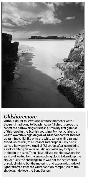
Despite being veterans of midge battles we lost heavily to this fighting force, which saw us off in minutes, scattering, in disarray, up the road, dragging partly assembled bikes. We paused to lick our wounds on the higher ground (where we should have parked up in the first place). We harbour a suspicion that Gallagher set them on us for taking the Mick about shooting from the car! Having rearranged our bikes, swatted any stragglers from the Midge Brigade and applied various unctions to our blotchy faces, we set off on the 16-mile trip to Gallagher Waypoint-4, Olshoremore. After sitting on the beach, nibbling at mueseli bars, we photographed the locals and set off back to the van, plotting a strategy to recover the van without further armed contact with the midge platoon.
This was accomplished by leaving the bikes back up the hill and charging at the van, at speed, and making an entry before they had smelled us. We then completed the last few miles into Scourie.
The next day we tackled the 4half km cross-country route to Tarbet, the departure point for ferries to the RSPB bird reserve of Handa. A sign at the start of the walk warned that the route was 'unmarked and suitable only for fit, well-equipped and experienced walkers, over challenging terrain'. They were not joking! We stumbled into Tarbet many hours later after a frustrating tramp though a maze of confusing lochans and peat bogs, never totally lost, but never knowing quite where the path was.
The highlight was a gate, standing in magnificent isolation on an outcrop of rock with neither wall nor fence to either side - it was one of the few times during our meander that we felt we might be on the path. We refuelled in the restaurant at Tarbet, quiet at this time of the year, as the ferry had stopped for winter. Sandwiches, treacle pudding and custard later, we set off in appalling weather for the 10-kilometre trudge back, relieved only by a kind soul who took pity on us a mile from the finish and dropped us back at the campsite. Considering the wet state we were in, it was an act of kindness that we will long remember.
next mountain of the ladder, Quinag. This included driving along roads that were high on little black arrows and low on width. Continental drivers worried about driving on the left in the UK have no worries here, you are either in the middle or in the passing place. At Drumbeg we chanced into the local grocery store which opened, Tardis-like, into something resembling Harrods' deli counter. Venison pate, stuffed olives, stuffed peppers, home-made coleslaw - it had everything! We scampered off and ate our purchases, looking out across the bay at Atlantic rollers driving over 60-foot outcrops in the sea, wild, magnificent, and the sun had come out as well! From there we sauntered the remainder of the way, taking in Clashnessie Bay (Gallagher Waypoint-5) to Clachtol, another geological masterpiece which features in all the texts on the subject.

The Highland Midge
Talk to anybody returning from the Highlands and the conversation will eventually involve midges. Read a Scottish Tourist Board publication and you are unlikely to find any mention at all - indeed when they conducted a survey on the impact of midges upon the economy they refused to make the findings public! For those who are unaware of the problem, the Highland Midge is a specific and separate species which conducts part of its life-cycle by biting warmblooded mammals, sucking blood out of the hapless victim and then using this to feed its developing eggs. It appears around the middle of June and disappears around mid-September. During the biting season, the midge is inactive in high light levels.
In photographic terms think of a light level requiring a smaller than f5.6 at the ISO speed rating (ie 1/125 for 125ISO). Thus midges will bite during the day providing the cloud cover is substantial, as well as under dusk, cloudless skies. The peak in biting activity is between 130 to 160 w/m2, equivalent to 9pm summer conditions or heavy low cloud cover or between 5am and 8am on a summer morning. The number of midges that rise from a suitable area of land is alarming. Figures of 500,000 midges trapped out of a control area of 2mx2m have been recorded and biting rates (of humans) of between 2,000 and 3,000 per hour are measured in experiments.
Under such an assault most humans are rendered helpless, army fighting units are effectively neutralised - small wonder then that the military have invested so much money in seeking a repellent. Midges must also be good photographers as they are most active at the very times when photographers like to be about, ie dawn and dusk. They rest up during the less photogenic hours, ready for the onslaught later.
Is it possible to do anything about midges? Probably not; certainly none of the topical applications seems to work very well even when they come with a history of working on wimpy southern midges and mosquitoes. Prevention is the best cure and a tight-fitting hat with a net covering the entire surface of the face is a successful, if inelegant, solution (don't even think about any model photography!). At least with digital capture you can cope with a less than perfect view down the eyepiece and check out the screen after capture.
Taking vitamin B1 complex for 30 days before exposure seems to help with the skin reaction to biting, but not prevent it. Avon Skin So Soft is reputed to be used by the Royal Marines as an excellent repellent. We did not see any Royal Marines but can assure the readers that it had no effect whatsoever, the midges absolutely loved it!

Clashnessie Bay Having driven past this small bay the day before, I was disappointed to see that some earlier visitors had spoiled the smooth sand and rendered a shoot impractical. I returned at first light the following day to find the tide had done its trick and wiped the sand smooth.
As I stood on the edge of the bay I was rewarded with a fantastic array of clouds against a blue sky and the water that surged and swirled around the rocks at my feet. A long shutter speed (two seconds) was enough to emphasise the movement and patterns of the sea water and the morning light did the rest.
Slioch When travelling along the edge of Loch Maree there are several Munros but none that hit you in the solar plexus quite like the first time you pass beneath Slioch (Spear). The setting certainly has a lot to do with it with the majestic beauty of Loch Maree, its Caledonian Pine woodlands and scattering of islands. On this trip if there was one mountain I would have begged to be topped in snow it would have been Slioch.
I walked about a third of a mile from the car across some of the deepest quagmire I have experienced to a small sandstone outcrop above and amidst the glacial boulder field left behind by the Late Devension Glaciation over 10,000 years ago. I waited over half an hour with this composition set on my ground-glass until the cloud structure above Slioch was perfect. It seemed to point towards the summit and my small erratic boulder was bathed in a milky sunlight, casting a thin shadow.

Stac Pollaidh Having seen the wonder of Stac Pollaidh and other mountains of this range from the opposite end of Loch Lurgainn I intended to head towards Strathcanaird and south towards Ullapool, but circumstances rapidly changed that plan. I had what I call one of my 'rear-view mirror moments'. It is often easy to get all too engrossed in what is in front of you and forget that if you turn your head (as it was designed to do) you can see things from an entirely different perspective.
This was one of those moments, but without the neck movements! I used my car rearview mirror and almost crashed the car! Stac Polliadh is one of those mountains that regularly and rapidly disappears and reappears behind foothills when you are travelling and I had all but given up on another good vantage point without climbing and I was not going to consider that option in the prevailing temperatures. The rear view mirror reminded me that I should stop the car from time to time and get out. The light, break in the cloud revealing a pocket of blue sky and vantage point were a gift.

B.P.P.A. LIMITED
The Society of International Nature and Wildlife Photographers (SINWP)
Clwyd Chambers, Clwyd Street, Rhyl, Denbighshire, LL18 3LA, UK
Company Reg 0392 2894 | VAT number 790 4289 05
Tel: 01745 356935
Corporate Partners


Newsletter: Subscribe here
SINWP Bird Photographer of the Year
London Photography & Video Show - Europe's Largest 'All-Welcome' Photographic Convention | Partner Societies | Privacy